- Products ProductsLocation Services
Solve complex location problems from geofencing to custom routing
PlatformCloud environments for location-centric solution development, data exchange and visualization
Tracking & PositioningFast and accurate tracking and positioning of people and devices, indoors or outdoors
APIs & SDKsEasy to use, scaleable and flexible tools to get going quickly
Developer EcosystemsAccess Location Services on your favorite developer platform ecosystem
- Documentation
- Pricing
- Resources ResourcesTutorials TutorialsExamples ExamplesBlog & Release Announcements Blog & Release AnnouncementsChangelog ChangelogDeveloper Newsletter Developer NewsletterKnowledge Base Knowledge BaseFeature List Feature ListSupport Plans Support PlansSystem Status System StatusLocation Services Coverage Information Location Services Coverage InformationSample Map Data for Students Sample Map Data for Students
Rendering Functions
The rendering plugin code must declare a single function that returns an object with one of these functions in it:
Both synchronous getGeoJSON and asynchronous getGeoJSONAsync functions return an object with GeoJSON data in the bodyproperty:
{
  contentType: "application/geo+json; charset=utf-8",
  body: geoJsonData
}
Only one of these functions must be declared. If both are present, GeoJsonDataSource throws an exception.
These functions accept a single parameter that is an object containing raw source data and provides access to various helpers and utilities.
Typically, you should use the synchronous function to convert raw data to the GeoJSON format. If your plugin can perform any asynchronous tasks, then you must implement the getGeoJSONAsync function. Examples of asynchronous tasks are HTTP requests to external APIs or usage of geometry data providers. To see a sample implementation of the Data Inspector Library sync and async rendering functions, see Plugin Examples.
Parameters
The getGeoJSON and getGeoJSONAsync functions accept a single params parameter. It is an object with these properties in it:
-
params.decodeResult { object }: ThedecodeResultobject provides access to raw data and has two properties:-
partitionId {string}: partition ID -
data { object }: raw partition data decoded by protobuf
-
-
params.logger { object }: The GeoJSON data source uses a logger that implements theILoggerinterface and is completely set up to log information to the console. The logger provides the following functions:// trace logger.trace("Trace message"); // debug logger.debug("Hello again log"); // log logger.log("Hello log"); // info logger.info("Hello again log"); // warning logger.warn("Hello again log"); // error logger.error("Hello again log");By default, the log level is set to
Warn, and you can change it at any point after theGeoJsonDataSourceinstance has been created:// Possible log levels are: Trace = 0, Debug = 1, Log = 2, Info = 3, Warn = 4, Error = 5. geoJsonDataSource.renderingPluginLogger.level = LogLevel.Info;or in the plugin code:
params.logger.level = 0;You can also pass multiple messages to any of the logger's methods:
logger.log("Log message", "Another log message", "One more log message"); -
params.layer { object }: Thelayerobject contains all layer properties. -
params.mapUtils { object }: ThemapUtilsobject provides a set of helpful converters that can be used while decoding data into GeoJSON. For more information, seeMapUtils. -
params.geometryDataProviders { object }: ThegeometryDataProvidersobject has async getters that are used to access various geometry data providers to map data. Currently, there are two data providers available:-
getSegmentAnchorDataProvider: an asynchronous method whose promise resolves with aSegmentAnchorGeometryDataProviderinstance. -
getRoadSegmentsDataProvider: an asynchronous method whose promise resolves with aBaseRoadSegmentsDataProviderinstance.
-
Referencing Source Data in GeoJSON
Rendering plugins work as converters from the source data format to GeoJSON. While a plugin can put some additional data payload to a GeoJSON feature's properties, it is not the best place to store original raw data. The intended use of properties is to configure visual styles and provide human-readable tooltips. For more information, see Style GeoJSON Visualization.
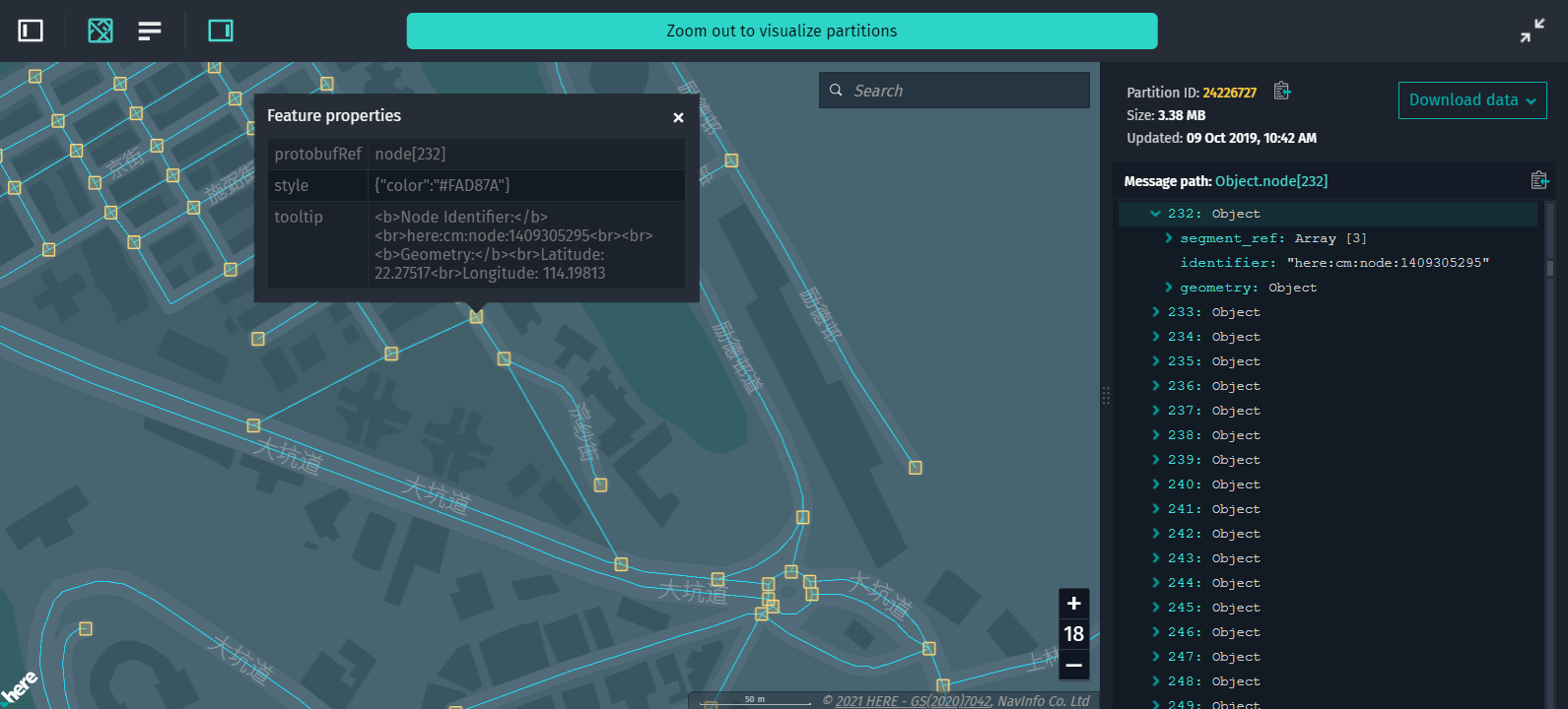
A proper way to provide access to source data is to map a GeoJSON feature (the output of the plugin) to a source data object (the input for the plugin). This can be done by providing the properties.protobufRef property for a feature. It contains a path to the original raw data property that this feature visualizes such as prop.someArray[34].prop2.
You can see the usage of properties.protobufRef in the sample plugin for visualizing HMC topology data. The source data root object has two arrays - node and segment, and the corresponding protobufRef properties are node[12] and segment[43].
If you look at the speed limit sample plugin, it generates a bit deeper path to the source data property: speed_limit[2].segment_anchor_index[137].
When you select a certain feature on the map, the Data Inspector Library DataInspector widget highlights the selected feature and moves focus to the corresponding source data node in the DecodedPanel, as in the figure below:
Note
According to the GeoJSON specification, FeatureCollection cannot contain properties. So, for visualization needs, you can specify identical protobufRef paths for multiple features.
Data Filtering
A rendering plugin may process large amounts of data and generate a lot of GeoJSON features. As a result, you can find it hard to pinpoint specific features on the map. Fortunately, plugins provide a mechanism to implement sophisticated filtering of visualized data.
Filters are implemented by grouping features and assigning each feature a set of tags. Tags are string values that can be either unique for each feature or can be shared between multiple features. Visibility of features with certain tags can be toggled in the Data Inspector's Data Filters panel. For this panel to show up, make sure that the enableFiltering property is set to true in the configuration of the DataInspector widget.
For a demo and implementation details of feature tags, see the plugin-hmc.js file that is shipped with Data Inspector example applications. This file contains the most recent rendering plugin code for certain HERE Map Content layers.
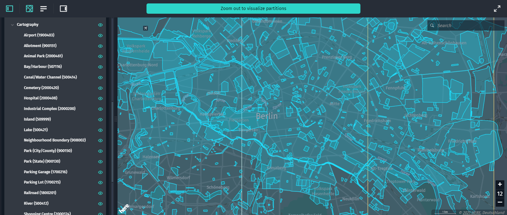
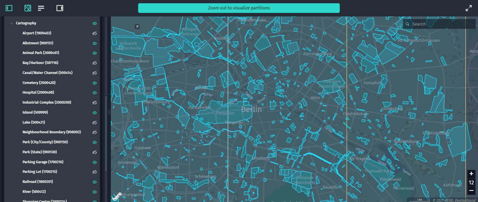
The images below show the difference between the visualization with all the filters enabled and the visualization with a few filters disabled:
In their simplest form, feature tags can be applied as an array of strings for each feature. For example, the following GeoJSON has two categories for free and paid parking lots. Note that this allows features to have more than one tag assigned, putting them in multiple categories for filtering.
{
  "type": "FeatureCollection",
  "features": [
    {
        "type": "Feature",
        "properties": {
            "featureTags": ["free"]
        },
        "geometry": { ... }
    },
    {
        "type": "Feature",
        "properties": {
            "featureTags": ["paid"]
        },
        "geometry": { ... }
    },
    {
        "type": "Feature",
        "properties": {
            "featureTags": ["free", "paid"]
        },
        "geometry": { ... }
    }
  ]
}
This results in the following filters with switches in the Data Filters panel:

Tags Hierarchy
You can organize tags into a hierarchical structure for more detailed filtering of features. This is achieved by using a pipe | separator in tag names. For example, a tag Buildings|Banks creates two tags - Buildings and Banks. Banks are nested inside Buildings. If you add a Buildings|Schools tag, Schools are also nested under the parent Buildings tag. In the Data Filters panel, you can toggle all of them at once by using the parent tag or each of the tags individually:

Tags can have an unlimited level of hierarchy depth, for example: Buildings|Educational|Schools|Preschools.

Default Tags
Sometimes a plugin can generate too much geometries for users to cope with, or some information is of less importance and should be visualized optionally. In such cases, it is useful to create all geometries but visualize only a certain subset of them.
For this, FeatureCollection supports a custom defaultEnabledFeatureTags property that specifies an array of those feature tags that are enabled by default. If it is not specified, then all the features are enabled. Pass an empty array to disable all the tags. For example, if you want to visualize roads but keep unpaved ones hidden by default, you can generate the following GeoJSON:
{
  "type": "FeatureCollection",
  "features": [
      {
          "type": "Feature",
          "properties": {
              "featureTags": ["Roads|Paved"]
          },
          "geometry": { ... }
      },
      {
          "type": "Feature",
          "properties": {
              "featureTags": ["Roads|Unpaved"]
          },
          "geometry": { ... }
      }
  ],
  "defaultEnabledFeatureTags": ["Roads|Paved"]
}
Note that you still have full control over tags visibility from the Data Filters panel, defaultEnabledFeatureTags only specifies a default state for tags.
Referencing Source Data from Multiple Layers
GeoJSON plugins provide an interface that allows retrieving data from different layers belonging to different catalogs. There is no limitation of layers that can be retrieved. For a working example of how data from multiple layers can be accessed through a rendering plugin, including sample plugin code, see the Access to other data source from a GeoJSON plugin example in Run Example Apps.
This interface provides a set of additional properties of the params object that is passed to the getGeoJSONAsync method:
-
getDependencies():Promise<VersionInfo[]>Retrieves the dependencies and their versions of the currently inspected version of the catalog.
-
getPartitionDataProvider(layer,catalogHrn?,version?): Promise<PartitionDataProvider>Retrieves a cross-layer partition data provider for the given parameters:
-
layer: A mandatory parameter that defines the target data layer identifier from where the partition data will be retrieved. The same layer and tiling types are supported as in the Data Inspector's Partitions List (currently, versioned and volatile layers with the HEREtile or generic partitioning scheme. -
catalogHrn: Defines the target catalog identifier. Defaults to the current catalog if not specified. If this parameter is a number, it is assumed to be the version parameter, andcatalogHrndefaults to the current catalog. -
version: Defines the version number of the target catalog to use. IfcatalogHrnis this catalog, the default is the currently inspected version. IfcatalogHrnis found from the dependencies of this catalog, the default is that version. Otherwise, the version must be given by the caller when the target layer is a versioned layer; for volatile layers it is not needed.The resolved layer, catalog HRN, and version used are logged to a browser console when this function is called. Nothing is shown in the Data Inspector user interface, it is up to you as a plugin developer to utilize the data.
The function returns a promise to the
PartitionDataProviderobject that has the following functions (if the catalog cannot be accessed or the layer type is unsupported, the promise rejects): -
getData(partitionId): Promise<ArrayBuffer>: Returns a promise which resolves to theArrayBufferwith raw partition data. The promise rejects if the data cannot be accessed. The layer content type may be anything, it is up to the plugin code to interpret the bytes (for example, it may be TXT or CSV or a custom binary type). -
getDataDecoded(partitionId, raw?): Promise<object>: Returns a promise to the partition content decoded as a JavaScript object. JSON, GeoJSON as well as protobuf content types are supported. The promise rejects with a detailed error if decoding cannot be done (for example, an unsupported content type, inability to get the schema for a protobuf layer, or a decode error). Ifrawistrue, then the enums and longs in the protobuf data will not be converted to strings (falseby default). Ifrawisfalse, then the returned object has exactly the same properties and values as the rendering plugin in the target layer would receive. This enables copy-pasting of the code from the target layer's rendering. -
decodeProtobufData(messageName, buffer, raw?): Promise<object>: Returns a promise to a JSON object decoded from the ArrayBufferbufferusing the givenmessageNameas the root message. The promise rejects ifmessageNameis unknown or data cannot be decoded with it. Ifrawistrue, then the enums and longs will not be converted to strings (falseby default). The schema declaration formessageNamemust be in the schema package linked to the layer. For example, this function can be used to decode arbitrary protobuf data stored in anAnyfield.Partition metadata or blobs are not accessed until the
getData/getDataDecodedfunctions are called.You must call
getPartitionDataProviderfor different layers and catalogs, store the returnedPartitionDataProvidersduring the lifetime of thegetGeoJSONAsynccall, and repeatedly call thegetData/getDataDecoded/decodeProtobufDatamethods of those when producing the GeoJSON output.Calls to
getData/getDataDecodeddo not impact what's shown in the Decoded Panel, it always shows the partition selected by the user.
-
Version Dependency Resolution
The Data Inspector Library has a built in mechanism for version dependency resolution between different catalogs and the corresponding versions of regional HERE Map Content (HMC) catalogs (Japan, China, or rest of the world) in the Data Inspector. This works for visualizing data like traffic or speed limits that contains no road geometry information.
For example, speed limit lines from the HMC Roads - Navigation Attributes layer must be mapped to road geometries from the HMC Roads - Topology Geometry layer. The new mechanism, in this case, aligns the versions of speed limit lines data and road geometry data to omit any errors and get the most accurate visualization. The Data Inspector reads layer dependencies and automatically retrieves geometry information from the corresponding regional HMC catalog.
Note that if you have no access permissions to the necessary HMC catalog, or the correct HMC is not defined in the dependencies of the layer to be visualized, the most recent HMC version is used by default (China or rest of the world).
For more information on how to set layer dependencies, see the CLI Developer Guide.